
FAQs
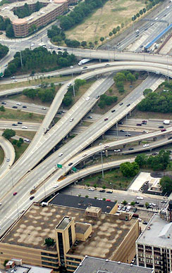
View AllThe Circle Interchange was built in the 1950’s and needs to be reconstructed because it is approaching the end of its design life. The majority of the work is replacing the existing infrastructure. Since the Circle Interchange is such is a vital link in the transportation network, we are taking this opportunity to update the current configuration which causes daily congestion and safety concerns. According to the American Transportation Research Institute and the FHWA, the Circle Interchange is the slowest and most congested highway freight bottleneck in the nation.
Didn't you just have a Public Hearing?
Since the public event on April 3, 2013, further detailed evaluation of the technical factors associated with the alternative(s) and their impacts on the community and environment has taken place. Alternative 7-1.C is being recommended for implementation.
The results of the evaluation process, along with all of the findings from previous steps of the study, are reported in the Environmental Assessment (EA) report. The EA can be viewed at www.circleinterchange.org, local libraries located within the study area, and the Illinois Department of Transportation’s (Department) Schaumburg office. A complete listing of these locations can be found on the project website. Comments on the EA will be accepted through July 12, 2013. After public comments are received and considered, a determination of the impacts is made. If, after completing the EA, it is evident there are no significant impacts associated with the project, a finding of no significant impact (FONSI) will be prepared.
What has changed with the Preferred Alternative since the public event in April?
Since the last public event, three geometric changes were incorporated.
The first increased the distance from Ramp NW to the adjacent residential buildings. The distance between the back of the retaining wall along Ramp NW and the Green Street Lofts building is now proposed to be 26 feet. The edge of pavement of Ramp NW is now proposed to be 32 feet from the Green Street Lofts Building. The second geometric change is the reinstatement of the exit ramp from eastbound Eisenhower to Taylor Street/Roosevelt Road. The third geometric change reduces eastbound Congress Parkway to three lanes below the Old Post Office.
What are the benefits of this project?
The preferred plan includes the complete reconstruction of the Circle Interchange and includes features that collectively improve the safety and mobility, improve the bridges, roadway and drainage system, and minimizes environmental impacts while enhancing the community connectivity on the local street network surrounding the interchange. By the year 2040:
• The improvement will create a safer environment for the motoring public by reducing the predicted number of severe crashes by up to 25%
• 50% reduction in delay for all vehicles over the course of the day
• A reduction of up to 5 million hours annually of drivers sitting in congested traffic compared to today’s conditions
• Savings of up to $620,000 daily, and over $185 million annually, in lost production from delayed travelers
• Reduction in idle time will result in up to 5,500 gallons of gasoline saved daily and nearly 1.6 million gallons annually
• One-third reduction in Greenhouse Gases
• Thousands of jobs created, which will also result in increased retail spending within the metropolitan area.
• Freight benefits include significant improvements to merging and weaving areas that are currently difficult for large trucks to navigate.
• Offâ€peak, daytime hours will not be as congested, which will increase the reliability for onâ€time deliveries
• There will be a better travel environment for passenger vehicles and trucks during inclement weather resulting from improved drainage, lighting, and roadway design
What happens if no-action is taken?
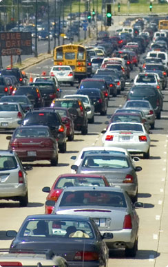
Currently, safety and traffic congestion at the Circle Interchange is a MAJOR problem.
• Today there are on average 3 crashes each day
• Northbound travel times are already extreme, where trips from 31st Street to the Circle (less than 3 miles) can take over 30 minutes.
• Delays caused by the interchange result in a combined loss of nearly 7 million hours annually.
• If no action is taken, by the year 2040 overall delay is anticipated to increase by over 50%. Northbound travel times are projected to increase by more than 30%, and southbound travel times are projected to increase by about 15%.
Why did you select Alternative 7.1.C?
We looked at approximately 30 alternatives during five rounds of evaluations. The evaluation process considered benefits, impacts, costs, and stakeholder comments. In the end, Alternative 7.1.C best meets design standards and the purpose and need of the project.
The other alternative discussed at the first Public Hearing was Alternative 15.4. This alternative was further evaluated since the April Public Hearing. Despite further evaluation, Alternative 15.4 has serious safety concerns including a curved alignment along I-290 reducing speed limits to 35 miles per hour, a roller coaster profile for eastbound I-290 with limited sight lines, and a dangerous combination of a steep down grade on a sharp horizontal curve for Ramp NW. Alternative 15.4 is an undesirable design for safety.
Changes have been made to improve safety. The only existing movement allowed today but not included in the preferred plan involves southbound Kennedy traffic turning westbound and exiting at Morgan Street. The only traffic movement which can exit at Morgan Street will be from northbound Dan Ryan along Ramp NW. Numerous alternative routes exist to accommodate the southbound Kennedy movement including Randolph Street, Monroe Street, Adams Street and Racine Avenue.
Access to Taylor Street/Roosevelt Road from both southbound Kennedy and eastbound Eisenhower will be maintained. The proposed ramp geometry has been improved to separate the ramp traffic from the mainline traffic further in advance providing a greater distance for drivers to make their decision, and the geometry also eliminates a substandard, dangerous weave that exists today.
How has IDOT involved the community and stakeholders?
As part of the IDOT’s Context Sensitive Solutions (CSS) process, local residents, business leaders, and representatives from transit agencies, community groups, medical districts, business groups, and local governments have participated in the Circle Interchange Study through a Project Working Group (PWG). The 92 PWG members represented 48 associations, special interest groups and agencies including two aldermanic wards and 17 organizations which represent the residents of the adjacent neighborhoods. 4,650 stakeholders have been identified and sent newsletter and postcards regarding the project status and upcoming events such as the public meeting and hearing. Four PWG meetings and one design charrette have been held in the study area. A project website has been maintained at www.circleinterchange.org to provide the latest information and allow stakeholders to submit comments. There was one public meeting held in August 2012, and a public hearing held in April 2013. There have been over 60 small group meetings that have taken place in the study area.
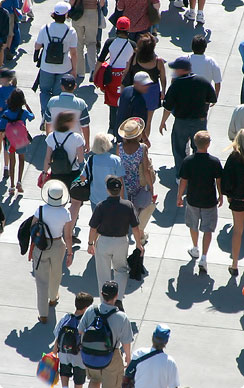
What are the benefits for transit, pedestrians, and bicyclists?
Bridges will be reconstructed at Taylor, Harrison, Van Buren, Jackson, Adams, Monroe, Halsted, Peoria, and Morgan. These new bridges will enhance the multi-modal transportation system of the surrounding street network with the inclusion of bike lanes, wider sidewalks, and improved access to transit. The CTA station entrance building located on the Peoria Street Bridge will be removed, the glass building will be updated, and an elevator will be installed to provide ADA access to the platform. The Peoria Street bridge will accommodate a wide plaza for pedestrians and bicyclists to cross over I-290, better connecting the community and improving access to the Blue Line. Also included is a mid-block pedestrian crossing and traffic signal along Halsted Street.
Will this project move the Circle Interchange off the list of most congested interchanges?
This project is addressing the need to replace highway infrastructure that has reached the end of its useful life in a way that also improves safety and traffic mobility within the confines of the Circle Interchange. Proposed improvements will provide significant benefits to highway users, users of the adjacent local roadway network, and pedestrians and bicyclists in the surrounding communities. Additional benefits will be realized when there are further improvements made to the adjacent highway system on I-90/94 and I-290. The cumulative benefits of these current and future projects will address the deficiencies cited in the ATRI study. The Circle Interchange project is an important first step toward overall highway system improvement in downtown Chicago.
How will this project improve traffic?
The preferred alternative will address the lane imbalance on I-90/94 by going from three lanes to four lanes in each direction through the Interchange, and double the number of lanes on the two most congested ramps (northbound I-90/94 to westbound I-290 and eastbound I-290 to northbound I-90/94). These lane additions, combined with smoother curves and flatter profiles on all the ramps, will enhance the mobility through the interchange, thereby increasing the traffic flow and reducing congestion.
How will this project improve safety?
The preferred alternative includes changes in access to improve safety. Specifically:
• The improvement will create a safer environment for the motoring public by reducing the predicted number of severe crashes by up to 25%.
• Southbound traffic heading to Taylor Street will exit north of the Circle Interchange, and access to Taylor Street from eastbound I-290 will be significantly lengthened providing greater decision and sight distance. Eastbound I-290 will merge directly onto southbound 90/94 eliminating the substandard weave with the westbound ramp to southbound I-90/94 and the exit to Taylor Street which will greatly improve the safety for each of these movements.
• Northbound traffic heading to one of the four downtown street ramps will exit I-90/94 south of the Circle Interchange and avoid mixing with traffic entering from I-290 and Congress. It will be physically separated from mainline I-90/94 by a barrier wall thus eliminating substandard weaves and allowing the slower exiting/entering traffic to be separated from the higher speed and more congested mainline lanes which will create a safer environment.
• Access to the Morgan Street exit will only be available for traffic traveling from northbound I-90/94 to westbound I-290. The elimination of the weaving and merging in this area will allow easier traffic flow and enhance safety. Northbound to westbound traffic will now exit on a two lane ramp which addresses the congestion issues and eliminates the potential for "cheaters" to attempt to bypass the queue on the south approach which is a source of numerous crashes. Additionally, an auxiliary lane has been added between Taylor and Harrison to allow traffic to safely enter from the northbound Roosevelt entrance ramp providing two lanes to westbound I-290 and one lane to eastbound Congress.
• The triple convergence issue and weaves near the Morgan Street exit ramp have been addressed.
How will the city and the community benefit from this project?
This project will reduce emissions and improve air quality. Improvements to the local street system will be bicycle and pedestrian friendly. For cross street bridges that will be reconstructed by the project, the Department will provide bicycle lanes in accordance with the City of Chicago’s master bikeway plan, wider sidewalks, and redesigned ramp entrances that are friendlier and safer for pedestrians.
What aesthetic benefits will result from this project?
This project will incorporate decorative/patterned form liners on the parapet walls and bridge piers, as well as uplighting on select bridge piers. In addition, landscaping within the Interchange area and along the local streets is part of the project. The Project Working Group members participated in a Design Charette to develop the overall thematic elements of the Circle Interchange.
How are noise wall locations determined?
For noise barriers to be considered, the adjacent land use must be impacted by noise levels from the proposed project (at or approaching 67 dBA for outdoor residential uses), installation of a noise wall must be both feasible and reasonable meaning they are constructible, and achieve at least an 8 dBA reduction for at least one benefited receptor. Based on the project’s noise studies, noise walls were found to be feasible and reasonable at six locations and have the potential to be implemented into the project. They are at: 770 Lofts; outdoor courtyard at Sangamon Street; Green Street Lofts; residential multi-unit between Racine and Loomis, north side of I-290; St. Patrick’s school and playground; and, the outdoor tennis courts at UIC.
The result is that noise walls can be installed if the benefited receptors vote to include one in the project. Currently the Department is soliciting viewpoints from the benefited receptors owners and tenants. The deadline for viewpoints has been extended to July 12, 2013.
Why isn't noise inside a building considered?
According to IDOT and FHWA traffic noise procedures, the evaluation of traffic noise impacts primarily focuses on outdoor activity areas affected by traffic noise levels. Activity Category B land uses (Residential) are always evaluated for exterior areas. Activity Category D includes certain land use facilities (see list below) that may have interior uses. Activity Category D is appropriate for use as a basis for determining traffic noise impacts for these uses where there are no exterior activities affected by traffic noise, or where the exterior activities are far from or physically shielded from the roadway in a manner that prevents an impact on exterior activities. It is specifically noted that Activity Category D does not apply to residential land uses and therefore an interior noise impact analysis would not be conducted for residences.
Description of Activity Category D: Auditoriums, day care centers, hospitals, libraries, medical facilities, places of worship, public meeting rooms, public or nonprofit institutional structures, radio studios, recording studios, schools, and television studios.
Will any land acquisition be necessary as a part of this project?
Construction of the proposed improvements for the Circle Interchange will require land acquisition at some locations. Approximately 0.1 acres of fee simple acquisition is required between Quincy and Jackson on the west side of the expressway. Several temporary easements for construction are proposed throughout the project, totaling approximately 0.2 acres from 6 parcels. In addition, the Department and UIC are entering into an agreement for the use and/or transfer of some property. The Land Acquisition process will follow the Uniform Relocation Assistance and Real Property Acquisition Act, as amended, and the IDOT Land Acquisition Procedure Manual.
What is the proposed construction schedule?
Reconstruction of the Circle Interchange will be a major undertaking and will take approximately 4 years to construct. The project is included in the Department’s FY 2014-2019 proposed Multi- Modal Transportation Improvement Program. The estimated cost is $475 million, which includes bridge rehabilitation, interchange construction, engineering for contract plans and construction. Of that, $151 million is included in FY 2014 for bridge replacement, interchange reconstruction, engineering for contract plans and construction to start date later this year.
Generally speaking, Stage 1 of reconstruction will include cross road bridges, Stage 2 will include I-290/Congress Parkway, and Stage 3 will include I-90/94.
Did you re-investigate Alternative 15.4?
Yes, Alternative 15.4 was re-investigated. Despite further evaluation, Alternative 15.4 has serious safety concerns and does not meet one of our primary criteria of providing geometry that is better than existing conditions. Alternative 15.4 has major concerns:
• The posted speed limit on I-290 would be 35 mph – resulting in unexpected slowdowns, increasing the potential for the number and severity of crashes
• The EB I-290 profile to go under Halsted, over the Dan Ryan, under Ramp NW, and over Ramp EN would have a “roller coaster” effect with sight lines limited to 35 mph (same crash concerns)
• Ramp WN would exit on the left side. This places slower exiting traffic in the fast lane (bad mix), and drivers expecting to exit on the right have to weave over 2 or 3 lanes in a short distance after coming out from under the Post Office.
• Ramp NW would have a very steep down grade on a horizontal curve. Additionally, this steep downgrade and tight horizontal curve is located immediately downstream of a crest curve over Harrison which is out of the line of sight of the approaching traffic. This is not a good design for a busy ramp.
• And finally, profile grades (or roadway slopes) on other ramps would be steeper than existing even if I-90/94 was lowered by 3 feet, risking potential for flooding at this major interchange.
Overall, Alternative 15.4 is an undesirable design for safety.
The design and ultimate construction of retaining walls in the City of Chicago require following the City’s Deep Foundation Procedure and Requirements. The Office of Underground Coordination (OUC) has very stringent requirements to obtain permits. For example, they require hand calculations to validate your computer calculations.
These procedures have been set up to deal with the construction of buildings next to buildings throughout the City. The Study Team is very familiar with these procedures.
The building vibration monitoring plan will consist of a Pre-Construction Condition Survey to identify existing conditions, cracks, bracings, etc.
Monitors will be installed. We anticipate two types: Blastmate for buildings close to the ROW, and Geosonics for those further away. Both will record data and can download information. The Blastmate has the capability to be connected to cellphones to send messages of vibrations above a pre-determined threshold.
The monitoring program will be conducted before construction begins to get a baseline, before and during construction.